
It’s only been a couple of hours since online check-in opened. Unhurriedly, I glance at the seating chart and there’s plenty of space available in the center section, but not a single window seat for the taking. Amateur hour strikes again!
Three hours into our flight, as final cabin checks are underway, I begin to get a little restless. The gent to my right, hogging that precious window seat, is still asleep, with the blind down. I tap him gently, podes abrir la ventana por favor? The good señor obliges, and I stretch my arm across him rather obnoxiously, eventually planting my phone against his window. The approach to Ushuaia is pretty spectacular, and if you’re smart, you’re going to secure that window seat as soon as you can…
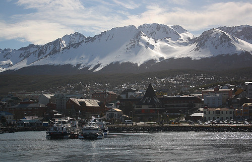
 Ushuaia‘s contemporary terminal building is impressive, no doubt, but what strikes you more is the very name of its aerodrome, Islas Malvinas International. As far as Argentina is concerned, this “southernmost city in the world” is also the administrative capital of the Falkland Islands. Both claims are somewhat dubious. The former is contentious, and the latter, sheer illusion. The Falklands remain firmly under British control, and the Chilean town of Puerto Williams, lies a few miles south of Ushuaia, making it the southernmost settlement on our planet.
But Puerto Williams is just that, a town. Ushuaia, on the other hand, is a well-established city by now, one that confidently carries the “southernmost” badge of honor. Both were set up for exactly the same purpose – to establish sovereignty in the region for their respective countries.
Ushuaia, a part of the Tierra del Fuego archipelago, sits at the point where the southernmost division of the Patagonian Andes meet the famed Beagle Channel. To the north, the province of Tierra del Fuego is separated from mainland Argentina, and the rest of South America, by the Straits of Magellan. And to the south, rounding it all off is Cape Horn, the southernmost headland of the archipelago.
And up until now I’d only read about these explorers and their navigational quests in geography texts, and traced their passages on a map. Its quite another thing to be actually sailing on the very waterway that was named after HMS Beagle, the ship that carried Charles Darwin and Robert FitzRoy.
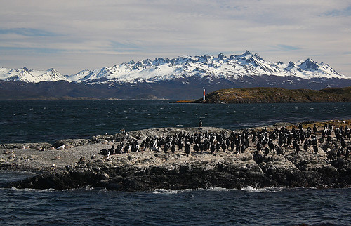
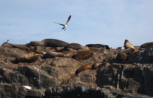
Cerveza Beagle in one hand and camera in the other, this voyage seems a lot less hectic than what Darwin and his crew probably experienced in the early 19th-century. Scattered across the cobalt blue waters of the Beagle Channel are several rocky islets, some home to Blue-eyed and Megallanic Cormorants; others hosting colonies of Southern Sea Lions, sharing their habitat with Kelp Geese. In the distance, Chile, and the snow-capped peaks of Tierra del Fuego‘s southern cluster…
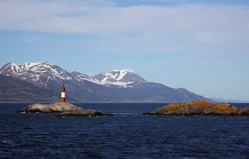
Before heading back to port, we sail past the iconic Les Eclaireurs Lighthouse, which most of my fellow travelers have by now assumed to be the very subject of a Jules Verne novel. They’re only about a hundred miles west of the truth.
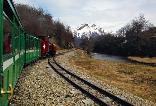
Ushuaia as a settlement is not particularly old. Dating from 1884, it started out as a prison colony; Argentina’s way of establishing a population that far south. The forced colonists ended up building much of the town, and in order to do so, a railway was laid deep into the forest for the supply of timber. The prison eventually closed in ’49, as did the railway a few years later.
Today, several decades after Ushuaia washed off its penal past, the old prison serves as a museum, and the railway has reopened as El Tren del Fin del Mundo or Train of the End of the World, ferrying visitors into Tierra del Fuego National Park.
The Southern Fuegian Railway, as it’s officially referred to, is diminutive in every respect. Hauled by a steam locomotive, its tiny carriages run on a track less than two-feet wide, covering a distance no more than 5-miles. Regardless, this undisputed southernmost railway of the world, offers an unparalleled introduction to the national park, charting a course inaccessible by road or trail.
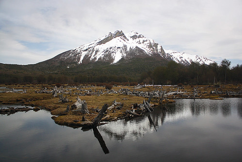
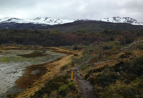
Tierra del Fuego is Español for “the land of smoke”. The Yámana were the original inhabitants of this land, and the first European explorers to the archipelago named the area after their campfires. Only a small population of Yámanas has survived today, all of them accounted for in neighboring Chile. But much of the land they inhabited remains largely intact, thanks in no small measure to the protected tracts that lie within Parque Nacional Tierra del Fuego’s 240 sq. mile footprint.
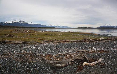
Much of the topography here was shaped by glacial erosion, so you can expect to find everything from gently meandering rivers to dense subantarctic forests made up of lenga beech; expansive wetlands bounded by calafate shrub to picturesque lagoons capped off by snow-covered mountains. A hike along any of the park’s well-marked trails is not merely a visual treat, but if timed right, also a complete escape to serenity…
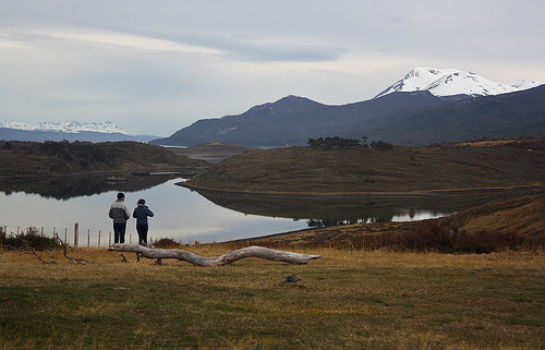
The Bridges family was one of the earliest European settlers to the region. Some 50-miles east of present day Ushuaia, they set up an estate for the rearing of sheep and cattle. Estancia Harberton came to be. Spread across 50,000 acres, and spanning lakes, islands, valleys and forests, it was the first estancia in all of Tierra del Fuego.
Out on a skiff one morning in the 70s, the grandson of Señor Bridges noticed a small colony of Penguins on one of his islands. Not making much of it, he just shrugged and sailed away. Fast-forward to twenty years later and a record-setting blizzard decimated the estate’s livestock population. Having sustained themselves on farming thus far, the Bridges decided it was time to turn their attention to Isla Martillo.
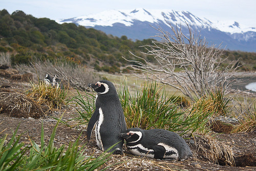
Meanwhile, that colony of Penguins had grown substantially over the years, with the birds migrating to the island every October to breed, molt and raise their offspring. Coinciding with their summer migration, Isla Martillo is open to visitors today, but thankfully human contact has been kept to a bare minimum, with only 20 people being allowed at a time, and no more than 40 in a day. If your willing to shed a few precious bucks for the privilege of walking amongst these magnificent beings, then Pira Tours is the company to approach.
Stepping ashore onto a pebble beach, after a 15-minute boat ride from the Harberton homestead, we are greeted by at least a dozen or more Gentoo Penguins, and in their midst, a sole King Penguin. The bulk of the island’s population though is made up by the Magellanic species of the bird, and we will witness them from even closer quarters as we make our way to higher ground. For now though, it’s a few hushed whispers and several gasps of amazement…
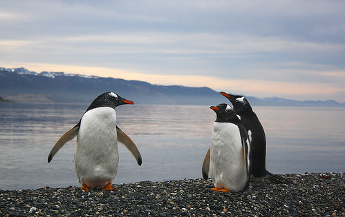
Isla Martillo lies in a part of the archipelago that is not only exceptionally beautiful but also completely untouched. So pristine is this habitat that despite the small group we are, and the limited time we’re going to spend on the island, I feel like we’re an intrusion here…
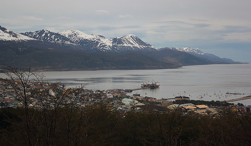
Back in Ushuaia, the pace is a lot more hectic. The city is in the midst of a grand celebration, commemorating 131 years of its existence. It’s main drag, Av.Maipu, is closed for a massive parade, and it also happens to be a public holiday in Argentina, which means both the city’s Maritime and Prison Museums are closed too. So I do the next best thing and hail a cab, to take me up to the base of Glacier Martial.
As mighty as they may appear, the mountains around Ushuaia, and across much of Tierra del Fuego for that matter, are not particularly high. In fact, the tallest of them, Mt.Darwin, tops out at just over 2300 meters. And that’s across the border in Chile. On the Argentine side, the peaks barely clear the 1500 mark. At 1050 meters, Mount Martial is the highest in the vicinity of Ushuaia, sitting directly north of it.
Its namesake glacier is now in retreat but continues to be the city’s main water source. At it’s base lies a lodge, a mini winter sports area, and a chair lift station, which, as luck would have it, is out of service. Still, it’s worth the ~100 Peso taxi ride there, for it offers incredible views of the city, the surrounding peaks, and the many little islands that dot the Beagle Channel. It’s also your one chance to get a grip on the lay of the land, if you happened to have missed out on that all-essential window seat 😉
A full set of pics from my visit to Tierra del Fuego can be seen here.

Wow
OMG! What an experience and what a post! Thank you for writing it. My mind is blown.
best line ever in a Bharat travel post … “Cerveza Beagle in one hand and camera in the other, this voyage seems a lot less hectic than what Darwin and his crew probably experienced in the early 19th-century.”
jabar dust mere yaar….maar dala