
Lest we forget Lima
A low haze hangs over the city, as you near touchdown at Jorge Chávez International Airport. Outside, the air is somewhat putrid and the eyes tend to smart. Traffic crawls along wide arteries and its not even 7 in the morning! You begin to question your very decision to stop over in Lima. But unlike countless others who skip it, in their rush to get to the Sacred Valley, you have in fact made the right choice! Lima’s worth more than just a second look – all it takes is one sunny day to lift the veil of smog, and a little bit of perseverance.
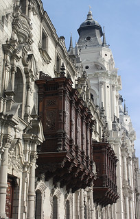
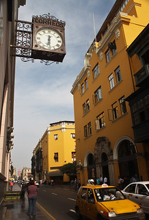
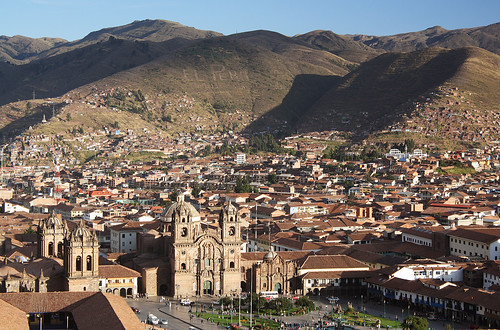
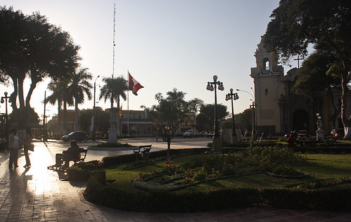
If the city’s new and hyper-efficient Bus Rapid Transit (BRT) system, and its up-and-coming Metro are anything to go by, the city has a lot to look forward to. Looking back, however, the city’s own past is securely preserved within Centro Historico, Lima’s landmarked historic quarter. A walk along Jirón de la Unión, from Plaza San Martin to Plaza de Armas, is an eye-opener, and a lesson to any civil servant on the preservation and upkeep of historic zones in large cities.
Public squares – no matter their size or importance – are spotlessly clean; lawns are beautifully tended, and pedestrian-friendly streets abound. The historic district is brimful with well-kept heritage buildings, some dating from the 16th-century, in styles ranging from Baroque to Neo-classical, and materials running the gamut from adobe to brick. In between, a myriad of colonial-era carved wooden balconies – no less than 1600 of them – makes up for the lull, if ever there was one…
The place to watch flowers
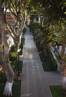
Located Southwest of the city centre, Miraflores, Lima’s upscale neighbourhood, translates to just that! And very early on, it seems, the district administration took cognizance, delivering acres upon acres of parkland to its inhabitants. So much so that today, a 6-mile stretch of green, carpets the bluffs overlooking the Pacific. A pathway conducive to biking and running, connects the various green spaces, passing along its way cliffside cafes, art installations, a skate park and a dirt-bike trail, and gorgeously-manicured parks, one of which even has replicas of the Nazca lines carved into its turf!
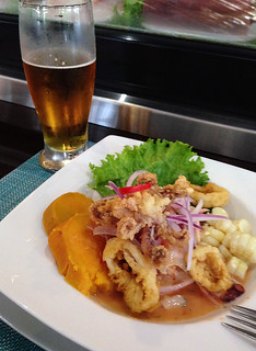
In the city’s thriving food scene, Miraflores holds a special place too. Chef Gastón Acurio, often regarded as the ambassador of Peruvian cuisine, opened his first restaurant in the neighbourhood, and since then some of Lima’s hottest culinary destinations have set up base here. Amongst them is La Mar Cebichería, Gastón‘s first specialty seafood restaurant (a brand that’s spread to six countries since), where the atmosphere is convivial, the prices are still affordable, and given that they’re only open from noon to 5 pm, the Ceviche is as fresh as it gets!


Check-in at Niños, and plenty of Mate de Coca
Cusco, the historic capital of the Inca Empire, sits at an elevation of 11,200 ft. Flying in from sea level (StarPeru, LAN and Peruvian all offer multiple departures out of Lima) does require some acclimatization – a day, possibly two.
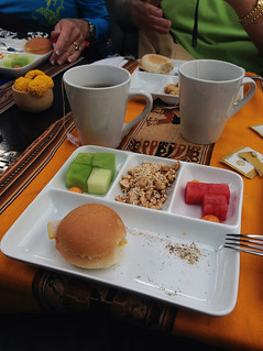
Extracted from the same plant as cocaine, and therefore deemed illegal in the US, mate de coca (coca tea) is drunk extensively in the Andes, as a preventive to altitude sickness. That, along with plenty of water, light meals and very little exertion is considered the most effective in adapting to higher climes. At the end of the day, everyone reacts differently to altitude, but one thing’s for sure – you will feel it!
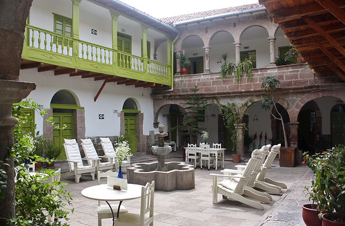
My first cup of the wonder brew was had soon after check-in at Niños, a cozy 20-room hotel on Calle Meloc, centred upon a charming courtyard, water fountain et al. Not only is the stay at Niños an extremely pleasant one, it is also towards a good cause. Set up by Dutch national, Jolanda van den Berg, proceeds from Niños go towards a foundation that looks after 600 underprivileged children in the Cusco region.
The cobblestone streets of Cusco are steep, and there’s just too much to see and take in, so you really have to make a conscious effort to restrain yourself on your first day there. For my part, I ambled along, orienting myself with the lay of the land, gazing long and hard at the many ornate balconies, and wandering into several alleyways, all of them intriguing and inviting. I even managed to hold off visiting the town’s main square, till magic hour drew me in…


The 08:04 Vistadome to Aguas Calientes
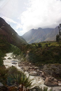
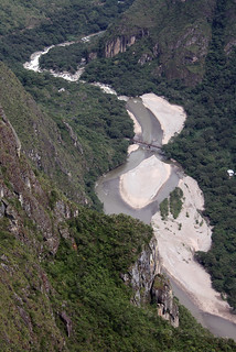
If Cusco is the gateway to the Inca Empire, the Sacred Valley is its heartland. Formed by the Urubamba River, a major tributary of the Amazon, the river’s Quechua name, Willkamayu, means “sacred river”, giving the valley its name! Everyone’s destination in the valley is of course Machu Picchu, and the only way to get there is on foot or by rail! Given another chance, and a lot more time, I would have chosen the 4-day trek along the Inca Trail. But if your itinerary doesn’t allow for it, the train is an extremely comfortable and fairly affordable option, giving you the chance to make the trip in a day.
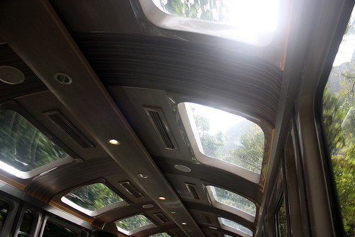
PeruRail offers frequent departures out of Cusco (Pachar these days, for operational reasons), across 3 classes of service, tailor-made to suit every budget. No matter what you choose – the “Expedition” train (formerly “Backpacker”) or the luxurious “Hiram Bingham” – the service on board is guaranteed to be excellent, and the views particularly dramatic! Panorama windows and skylights are standard on most carriages – use them well, for you never know what you might chance upon…
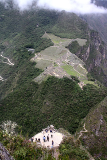
To the very top of the young mountain
The little town of Aguas Calientes (Machu Picchu Pueblo) is the railhead for Machu Picchu. Settled along the Urubamba River, and known for its hot springs, the town lies at an altitude of 6690 ft, making the task of breathing a lot easier! From here, shuttle buses ferry visitors to the Machu Picchu archeological site, which lies some thousand feet higher, and ~6-km away.
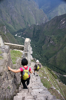
A checkpoint controls access to Huyana Picchu (young peak), the mountain that is commonly seen in photographs, towering over the Inca ruins. Only 400 people (in batches of 200) are allowed up the mountain in a day, and reservations for the same should be made well in advance. With 1400 stone steps to the summit, the climb is arduous, to say the least, and the mountain has, in recent years, claimed 23 lives. Unfortunately, the descent isn’t any easier!
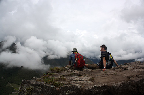
Once atop though, it all seems worthwhile. From that vantage, the Urubamba, some two thousand feet below you, wraps around like a serpent; the archeological site itself looks minuscule, and having finally contextualised the geography of the area, you begin to appreciate just why the Incas chose that particular location for a citadel…
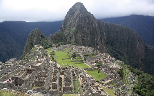
The Lost City
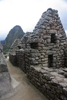
The Incas built Machu Picchu in 1450, only to abandon it a century later, following the Spanish conquest. It remained undiscovered (hence “Lost City of the Incas”) till 1911, when, thanks to American historian and explorer, Hiram Bingham, it was given worldwide attention. The restoration of the site has been a labour of love since, and continues to this day. Declared a World Heritage Site in ’83, and more recently, one of the New Seven Wonders of the World, Machu Picchu certainly lives up to its name, and the Peruvians have done a remarkable job maintaining it so.
Recinto del Guardián or the Guardhouse is one of the highest points within the citadel, and expectedly, the view from there is the subject of many a photograph taken at Machu Picchu. It also helps one understand the layout of the city; its upper and lower town, urban and agricultural sectors, and the location of its many terraces. The Incas, as it turns out, were no strangers to earthquakes. The very fact that the city survived several quakes, and the passage of time, is testament to their construction skills and building techniques.
They were also master planners. It is estimated that a quarter of the land at Machu Picchu was reserved for farming. The terraced farmland, kitted out with sophisticated channeling systems, not only provided more land to grow crops, but also protection against invaders (steeper slopes to ascend!) and reduced soil erosion, which in turn lessened the likelihood of landslides.
Plazoletas, pasajes and twelve-sided stones.
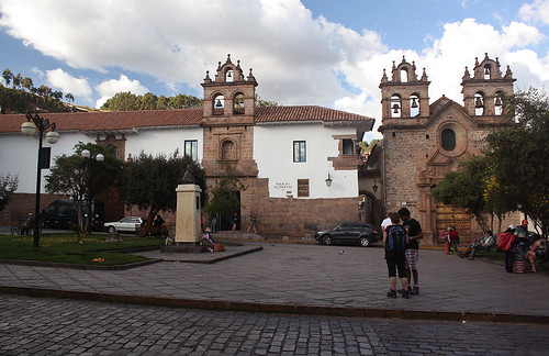
In Inca times, Plaza de Armas was known as Huacaypata. It was twice as large then, and spawned roads in four different directions, leading to the far corners of the Inca Empire. Defined today by the beautiful Cusco Cathedral and the magnificent Iglesia de la Compañía de Jesus (a rival Jesuit Church), it continues to be the centre of life in Cusco, and no visit to the city is complete without it. But smaller plazas abound in Cusco, most of them set up adjacent to the many Churches, Convents and Monasteries that the Spanish built, and almost all of them adhering to the same level of upkeep as the town’s main square.
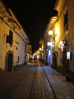
The historic heart of Cusco is compact and easily walkable, and a great way to feel the city’s pulse is to spend time in its many unsung plazoletas. Indigenous folk in colourful garb strut their Llamas at every other street corner; young men can often be seen rehearsing traditional dance forms; vendors sell local artwork and every kind of Alpaca wool product imaginable, while local buskers serenade the passers-by. All of this, against the backdrop of gorgeous Baroque Cathedrals!
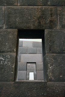
Cusco, as we know it today, can be said to be part archeological, part colonial. The Spanish essentially built their city on Inca foundations, and nowhere is this better illustrated than at the remains of Templo de Qorikancha, which exist within the cloister of the Santo Domingo Monastery. The Cathedral the colonists built, on the site of the Inca Temple, was all but destroyed by major earthquakes, but the mortarless Inca walls, built of precisely cut, tightly interlocking stone blocks stood upright through it all!
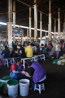
Being one of the most visited cities in South America, Cusco can, at times, seem overrun by tourists. For a more “local” experience, head to Mercado Central, Cusco’s bustling central market. Walk the aisles within the sprawling shed, where everything from poultry to Peruvian peppers, household items to cheap eats are available for sale. Even if you’re not shopping for anything in particular, stop by for some fresh fruit juice – an inexpensive and extremely generous serving – and take in the frenzy of activity and riot of colour around…
Cusco’s terrace
Having adjusted to the altitude, consider setting your sights a little higher! To the west of Plaza de Armas, and at least a few hundred feet higher, lies Templo San Cristóbal, an early 17th-century church, comprising a single bell tower, built of adobe. Architecturally speaking, it isn’t a destination in itself, but the spacious plaza that adjoins it, easily offers the best views of Cusco!
To the north of Plaza de Armas is Barrio San Blas, considered by many to be one of the most atmospheric neighbourhoods in the city. Although at a lower elevation than San Cristóbal, the barrio is perched on a hill, and characterized by steep streets and narrow passages, overflowing with artist studios and galleries, pubs and cafes. The neighbourhood gets its name from Templo de San Blas, the oldest Parish in the city, and the plaza it opens onto, offers generous views of Cusco’s southern extremes. A walk through this quaint barrio by night pays rich dividends!
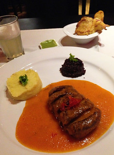
There’s very little not to like about Cusco – without doubt, one of the most charming towns I have ever set foot in! Even in the most epicurean of pursuits, Cusco scores highly, probably second only to Lima, in terms of an abundance of restaurants and the high quality of food and drink on offer. Given its distance from the coast, you wouldn’t want to seek out Ceviche here, but consider getting Lomo Saltado at Tunupa, Cuy (if you can hack it!) at La Cusqueñita Pikanteria, a solid breakfast at Cicciolina, or then, since your in Llama land, Alpaca Steak at Marcelo Batata…
Bohemian in Barranco
Less than 4 km² in size, Barranco is one of the smallest districts in Lima. Located just south of Miraflores, it was settled in the late 19th-century, and soon become a summer retreat for the city’s well heeled. Its coastal location attracted the likes of writers and artists, and continues to do so to this day. In recent times, designers and musicians have joined their ranks, and today, the district boasts a dozen art galleries and the city’s only contemporary art museum.
For the longest time, Barranco tried hard to stay independent of the city, but eventually succumbed to the metropolis that is Lima. Even so, it continues to have a laid back, village-like feel to it, with very little modern development, plenty of bougainvillea-lined cul-de-sacs, multihued colonial mansions, and towering old trees. The decidedly slower pace extends to its main square too!
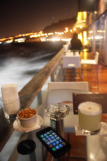
Barranco is Spanish for ravine, and Bajada a los Baños is the pathway that runs through it, literally! Hemmed in by cafes and restaurants on either side, the tree-lined walkway passes under Puente de Los Suspiros or Bridge of Sighs, a wooden bridge built in 1876, and a popular spot from which to watch a golden sunset. Bajada a los Baños eventually leads to the waterfront, on which is nestled Cala, a lounge bar that serves a mean Pisco Sour and expansive views of the Pacific. No matter what your choice of drink, this is a great spot to toast the beginning or end of a trip to a truly fabulous country like Peru!
———————————————————————–
More pictures of Lima, Cusco, the train journey to Aguas Calientes, the trek to Huyana Picchu, and Machu Picchu can be seen on my Flickr.

Magical!
Sounds and looks fascinating…Peru is definitely on my bucket list…thanks for the wonderful reinforcement your article provides!
Lovely narration and pics. Always been wanting to go there, but S. America seems to be on another planet from where I sit!
Caramba! This very informative blog and your superb pictures have effectively sold Peru to me; I’m going to go there before I die or die trying!