
Rush hour, Mexico City
Securing a gate at Benito Juárez International is almost as difficult as finding a perch for your feet during rush hour in Mexico City – and the rush starts early, very early! The Metro system is thoroughly efficient though – trains arrive every couple of minutes – and at 2 pesos a ride, it is also one of the cheapest in the world! The airport is located just 5-km east of the city centre, and so even on a short layover, it is perfectly feasible to make a trip downtown – one that’s bound to whet the appetite and make you want to come back for more.
Mexico City, as we know it today, was built by the Spanish on the ruins of Tenochtitlan, the capital of the Aztec Empire. As it was in Aztec times, the city is centred upon Zócalo, the sprawling main square, Latin America’s largest! The Metropolitan Cathedral, a stunning baroque structure, defines the square’s northern boundary. To the east sits Palacio Nacional, which, due to an ongoing protest, has been closed to the public since May! Two near-identical Federal District buildings make up the southern periphery, and to the west are a series of neocolonial commercial buildings. In the centre of it all, a larger than life national flag flutters in the wind. With the first few rays of sunlight piercing through, Zócalo is a sight to behold!
Located just west of Zócalo, the Art Nouveau lobby of Gran Hotel de la Ciudad de Mexico is absolutely stunning, and worth a detour from the main square. Formerly a department store, and presently a hotel, it was featured in the film “Frida”. Their rooftop restaurant doesn’t open till lunch, unfortunately, so if you’re looking for an al fresco experience, you have to make do with the nearby Holiday Inn. Thankfully, the price for a buffet there is a steal, and the views irresistible. The breakfast, as it turned out, wasn’t too shabby either!


There’s more to the name
For many, Chihuahua refers to the smallest breed amongst canines. But the dogs themselves are named after the State where they were first bred, Chihuahua, Mexico’s largest! The word, far removed from what one might expect, comes from the Nahuatl language, meaning “confluence of rivers”. Chihuahua‘s capital city is also its namesake, but your likely to see more cowboys there than the aforementioned animal!
Sitting at an altitude of 4600 ft, the city of Chihuahua has the look and feel of a frontier town in a Spaghetti Western. Hat-donning Vaqueros roam its streets, and every other store sells high leather boots, checked shirts and Wrangler jeans. Surrounded by a desert (also a namesake!), Chihuahua‘s environs do tend to be dusty and brown, so the longevity of the leather is ensured by shoe shine men, several of whom dot the main square, and practically every little plaza in the city. Never mind what Hollywood would have you believe, the Vaqueros – a Spanish word for livestock herder – have been around a lot longer than the Cowboys north of the border!
Our overnight stay in Chihuahua was at Hotel San Felipe El Real, a 19th-century villa turned bed and breakfast, with six rooms in all; a quaint courtyard, family-style dining room, and warm hosts. The inn has retained most of the furniture, decorative objects and collectibles from owners past, giving one the feeling of being in someone’s home, rather than your run-of-the-mill hotel.


Primera clase to Los Mochis
On its own, Chihuahua is a pleasant enough town to visit – good upkeep, an attractive historic quarter, a lot of urban renewal projects in the works, and a laudable marketing effort. But being the terminus of the Chihuahua Pacifico Railway is what really puts the town on the map, making it as relevant to the intrepid traveler as it is to any rail enthusiast. Like many before me, it was the prospect of a journey on El Chepe, as the train is fondly referred to, that drew me back to Mexico.
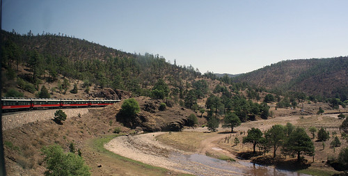
Considered by some to be one of the most scenic in the world, Ferrocarril Chihuahua al Pacifico is a 673-km (418-mile) route that connects Chihuahua in Mexico’s high desert to Los Mochis on its Pacific Coast, traversing the country’s famed Barranca del Cobre (Copper Canyon) along the way. Trains depart from either end at 6 AM, made up of first and second-class accommodation, with a full-service dining car in-between. One-way fares range from $115-180 and the journey takes anywhere from 14 to 16 hours.
The first 100-km or so is through the Chihuahuan Desert, characterized by chocolate-brown foothills – often with striking formations – and gold, straw-like hay, stretching for miles on end. Cuauhtemoc, named after a former Aztec ruler, and home to the one of the largest Mennonite communities in the world, lies at the western edge of the high desert and marks a significant shift in the topography.
Despite the desert that its known for, the State of Chihuahua is one of the largest agricultural production centres in the country, and the area west of Cuauhtemoc alternates between grain silos and apple orchards. Continuing further west, the train begins a gradual climb towards San Juanito, with oak-pine woodland adding texture to the ascent.


The Canyon to beat them all!
An hour shy of San Juanito, one gets a first glimpse of the Sierra Madre Occidental, also referred to as Sierra Tarahumara, the mountain range that is home to Barranca del Cobre. With the Continental Divide having been crossed thrice since Cuauhtemoc, Creel, the principal town of the Copper Canyon, is reached around noon. From there, it’s a final push to Los Ojitos, which at 8,071 ft is the highest point on the line. The descent down from the summit begins in full earnest thereafter, and at El Lazo, the train crosses under itself by means of a spiral.
On our run down to Divisadero, the weather changed rather suddenly – driving rain, which turned to hail by the time we reached the station! On a clear day, however, the overlook at Divisadero offers unhindered views of the Cobre, Urique, and Tararecua Canyons, the Copper Canyon system made up of six unique canyons, which in parts are deeper, and overall much larger than the Grand Canyon in Arizona!
If time permits, it is advisable to break journey along the way, and Posada Barrancas at Km. 626, is the perfect place to do so. The railhead to at least 3 lodges, all located along the canyon rim, it is where many tourists alight, to partake in canyon hikes (for the more adventurous) or simply to watch a sunrise. Several tourists board here too, and the section that awaits them – between Bahuichivo and Témoris – is by far the most dramatic!
In the 30-odd miles it takes to descend to the village of Témoris, there is a corresponding altitude drop of over 2,000 feet. Two back-to-back, and equally spectacular, 180-degree turns ease the rail alignment into the Rio Septentrion Canyon, and to really take it all in, one needs an extra set of eyes, and for those of us juggling cameras, a spare hand!
Further west of Témoris, the descent is more gradual, but no less beautiful. The terrain changes once more as the railway crosses into the State of Sinaloa. Characterized by subtropical dry forests – the transition belt between the Sonoran Desert to the north and the Sinaloan dry forests to the south – the area is one of the driest in the country, with the land all but parched. Like several places in India, it begs for rain, and would no doubt change colour when the monsoon arrives…


The Place of Turtles
Los Mochis, the western terminus of El Chepe, is an agricultural and industrial city in the State of Sinaloa. Often referred to as the “Place of Turtles” (am not sure why!), the city is a little over a century old, and hence lacks the rich heritage or reputed monuments of the more storied cities in Mexico. But given its location, close to the Sea of Cortez, it definitely has the laid back, easy-going feel of a coastal town, complete with palm trees and the scent of the ocean.
Not far from where we stayed (Hotel Corintios on Av. Gral Álvaro Obregón) was Plazuela 27 de Septiembre, the leafy main square of Los Mochis, which, like the one in Chihuahua, was undergoing extensive renovation at the time. Across from the plaza was a whitewashed church, Sagrado Corazón de Jesús, a city landmark, which wore a festive look following Sunday Mass.
The street between the church and plaza was closed off for a fair, which hosted vendors of all kinds, including Cocos Helados, a street cart selling coconuts, with the most innovative toppings imaginable. Coco con Cacahuates o Riel was the one I ordered – Coconut meat (the white fleshy part!), mixed in with roasted peanuts, bits of tamarind, limejuice and hot sauce – one of the most interesting concoctions I’ve ever sampled, and a meal in itself!


Mariscos in Maviri
A 25-minute ride west, on an old, hand-me-down Ford school bus, brings up Topolobampo, one of two Sinaloan ports. The sleepy hamlet adjoining the port is worthy of a stroll, with a handful of seafood eateries and a ramshackle pier offering Dolphin-sighting excursions in Bahia de Ohiura, the protected bay east of Topolobampo. Instead, continue on the local bus towards Playa Maviri, an island that lies about 11-km southwest of the port, and is reached by means of a scenic causeway.
Bound by the Gulf of California on its west and Bahia de Topolobampo on its east, Playa Maviri is essentially a collection of seafood shacks lining its soft sands, and offering views of the bay or the ocean, depending on where you choose to sit. It is where local Sinaloans flock to, and where your unlikely to spot a gringo, or any tourist for that matter.
At Restaurant Miramar, parents can safely let their kids play in the sand or wander into the water, whilst focusing on their food. Located on the bay – where the waters are shallow, warm and calm – the restaurant also serves a great plate of refreshing Ceviche Mixto!


And finally, Guadalajara
As famous a journey as it might be, it is somewhat ironic that El Chepe is one of the last operating passenger trains in a country as vast as Mexico! But like many of its Latin American counterparts, Mexico too shrugged of its rail network a few decades ago, in favour of modern buses, plying on a network of new highways. And so, our only option to get to Guadalajara was to take the bus!
With seating for just 24 passengers, in a spacious 2+1 configuration, ETN Turistar‘s 9:05 pm departure from Los Mochis, offered us in-seat entertainment, WiFi, a very generous recline, and even a packed breakfast for the overnight journey to Guadalajara. At half the price, it delivered us to our destination, some 900-km (550-miles) south, in less time than it took El Chepe to reach Témoris!
Guadalajara, the capital of the western state of Jalisco, is also the second largest city in Mexico. One of the fastest growing economies in the country, it has long been regarded as one of its cultural hubs; home to the Mariachi form of music, and a gateway to Tequila country, amongst others. In fact, the only other passenger trains in existence in Mexico, both operate from Guadalajara, along the “Tequila Route“, giving visitors a ringside view of the blue agave fields, and taking them on distillery tours, with plenty of Tequila tasting included!
Catedral de Guadalajara, a Roman Catholic Cathedral dating from the early 17th-century, dominates Centro Historico. The Renaissance-style structure has survived several earthquakes since, and today forms the centrepiece of Guadalajara downtown, surrounded by no less than three plazas. Guadalajara‘s City Hall, Government Palace, the State Legislature and Judiciary buildings are some of the other landmarks in the immediate vicinity.
Together, they comprise one of the best-maintained historic districts I’ve ever had the privilege of strolling through! Given that it’s all I saw of the city in the short time I had there, I came away most impressed. Guadalajara, like the rest of the remarkable nation it belongs to, warrants another visit…


A full set of pics from Mexico City, Chihuahua, Los Mochis and Guadalajara can be seen here, and pics from the rail journey can be seen here.

No need for elaborate and heavy guides if one ever lands up in this part of Mexico, just open this page on your tablet! Entertaining as well as informative – thanks!