
To most visitors, Casa de la Literatura Peruana is nothing more than an architectural landmark, sandwiched between the Government Palace and a baroque monastery, in Lima’s historic quarter. The more discerning know of it as a library, famed for its exquisite stained glass skylight. But very few are actually aware that this was, in fact, Lima’s main train station. While regular passenger service ceased decades ago, the Ferrocarril Central Andino or Andean Central Railroad still runs a monthly service from here, to the Andean city of Huancayo. And on this characteristically foggy October morning, I’m here to board one of their last departures for the 2019 season. The Lima metropolitan region is a lot larger than I can recall, and this far east, more built up than I would ever have expected. Chosica, home to Ferrocarril Central Andino’s operational and maintenance hub, is over 50-km (31 miles) east of the Capital, and only then are we rid of its scruffy outskirts. Tickets and credentials all checked, breakfast is now served at our seats, but is far from filling. Good thing I carried fruit from the hotel this morning.
San Bartolomé at km 76 is the first of two stops we’re allowed to disembark at, and by this point we’ve already gained close to 5,000 feet in elevation. The first of many switchbacks or zig zags to follow, San Bartolomé is the only single ended one, meaning that all locomotives must be turned here. The halt is long enough for our hosts to squeeze in a mini cultural performance, which we’re assured is the first of many to come.
 Heading out of San Bartolomé, a series of horseshoe curves eventually lead us to Puente Carrión, the longest and highest bridge on the line. Spanning ~715 feet, and perched 250 feet above a deep ravine, it is, from every account, a lot more impressive to look at from the ground up. There’s a noticeable gain in height after Balta at km 94, courtesy of the spiral tunnels that lie inbetween. We’re now looking down at Balta yard, where we were only minutes ago, with our intermediate route visible as well.
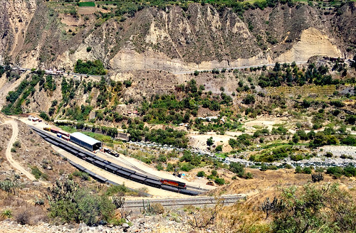 A common technique employed by several mountain railways across the world historically, zig zags are, as the name would suggest, a means to gain height, without having to bore through a mountain. Zig zags have their limitations though – restricting the very length of a train – and for Ferrocarril Central Andino or FCCA, which earns its bread and butter from the carriage of freight, that is a big limitation. But so adept are they at high altitude railroading, that it’s an absolute treat to watch them nimbly go about coupling and decoupling freight wagons on steep inclines, setting up chocks to prevent them from rolling, and throwing the switches on the zig zags, without so much as pausing for a breadth. It’s a more cost effective solution, no doubt, but where they do exist, zig zags are also a marvel of railway engineering to experience. And so it goes at Viso, the first full switchback of six on the FCCA, where all three levels can be observed at the same time.
 For a good measure of its route up the Andes, the railway carves a path through the Rimac River Valley, with Carretera Central (the central highway) paralleling much of the alignment. At times, the Rimac morphs into a narrow canyon, and the railway is forced to find a way through it. The challenging nature of the terrain is best appreciated at Tamboraque, where the middle and upper sections of the switchback pass through an outcropping in parallel tunnels.
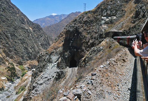 Of the many impressive bridges on the route – there are 55 in all – Puente El Inferniello at km 129, is easily the most dramatic. Between tunnels 35 and 36, whose portals bookend the 63-meter long bridge, our train darts into the cavity between two vertical cliffs, quickly enveloped by darkness once again, before we’ve even had a moment to register this staggering feat of engineering. Quite fittingly, the bridge’s name translates to “Little Hell”.
 There are two classes of accommodation on the train; classic and tourist, with tickets being sold by a handful of tour operators, once dates have been released by the FCCA. And while the price difference between those classes is not insignificant, there is simply no better way – even if it means fighting to get a spot – to enjoy the beauty of this railroad, or the terrain it passes through, than the observation car, which is only available to tourist class passengers.
 After Chinchan at km 160, we sweep around a large horseshoe curve, the railway climbing steeply up the other side of the valley. Looking back, one can see the remnants of an old wye or triangle, which was probably used to turn locomotives during the steam era. Much of the Lima – Huancayo route boasts gradients of up to 4.7%, which, when expressed in units, translates to a foot gained in height for every twenty one feet traveled. Back in the day, Chinchan would have served as a base for “helper” operations, wherein a locomotive would be tagged on at the rear to help push trains up the stiff grade leading to the summit.
 As the Rimac Valley opens up again, the absolute might of the Andean Central Railroad can truly be admired. The rail alignment clings to a narrow ledge along a sheer cliff face, whereas the central highway takes a more cautious approach, deep down below, along the valley floor.
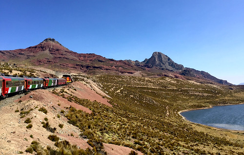
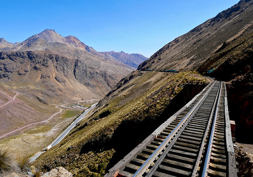 Craggy sandstone bluffs now dominate the terrain, and through them we pass a quick succession of tunnels. Of the 68 on our route today, 8 are crossed in less than a two-mile span leading upto Ticlio. Of the many beautiful locales along the route, Ticlio, with its namesake mountain and lake, might well be the most enchanting; the stark but stunning Andean topography on full display here. Till the spur to the nearby Volcán Mine closed recently, Ticlio also held the distinction of being the worlds highest railway junction.
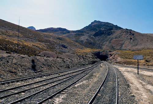
 Like every other tunnel along the way, there is nothing noteworthy about the western or eastern portals of Galera, but within that 3/4 mile long tunnel, the railway crests its summit at 4783 meters (15,692 feet), and also crosses the Continental Divide. We’re now in the Region of Junín, and we pull into Galera station for a halt.
 As early as 1851, there was talk of a railroad from the coast deep into the Andes, but it wasn’t until 1870 that construction finally commenced. It took eight years for the first section to open upto Chicla, 141 km away. Then came the War of the Pacific, effectively putting a spanner in the works, with the line being extended piecemeal, as and when funding became available. Eventually, it took over 38 years for the 346-km or 215-mile route to finally reach Huancayo, nearly bankrupting the Peruvian economy in the process. For 98 years thereafter, it remained the highest railroad in the world. In ’06, Galera lost out to Tanggula station on the Qinghai – Tibet Railway, but it’s unlikely to be surpassed as the highest station in the western hemisphere, anytime in the foreseeable future.
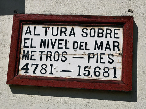 Even if you’re well medicated, and not suffering from AMS by this point, stepping off the train at Galera, you’re definitely going to feel the altitude, with every bit of movement feeling like an absolute chore. Never enough of a deterrent though, for those seeking that all-essential photo op.
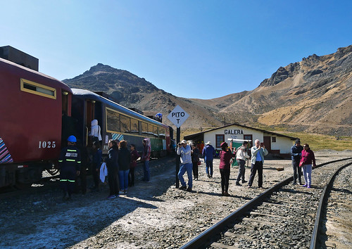 Pulling out of Galera, everyone retires to the safe sanctuary of their tourist class carriages, leaving the observation car practically empty. No complaints there. The observation car includes a bar and lounge area, and a complimentary Pisco Sour for every ticket holder in tourist class. Despite my better judgement, I decide to indulge.
 Luckily, it’s all downhill from this point on, and the free bevvy is not a particularly large serving. Our descent is no less spectacular, with sweeping views of the valley, and lofty snow-capped peaks visible in the distance. I try and imagine what it’ll be like to experience this railroad in the winter.
 The FCCA derives most of its revenue from the haulage of copper, lead and zinc, supplemented somewhat by cement and fuel; a majority of it transported down to the Port of Callao. The vast mineral reserves in the area have obviously not escaped global attention, and after having made our initial descent down from Galera, looming large on the horizon is Minera Chinalco Perú, a Chinese-owned copper mine. An eye sore on the largely unblemished Andean landscape, no doubt, it’s also a reliable source of income for the railway, and the region’s economy at large.
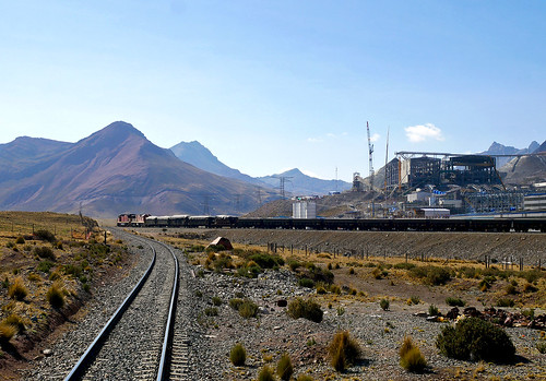 We’re now in the heart of Peruvian high mining country, charting a course through the Yauli River Valley, and its namesake town is one of many little mining settlements that dot the rail route; each with its own little football field, an iglesia, and often times, even a statue of Christ the Redeemer.
 La Oroya at km 222 is the largest town in the valley, and also the junction for the FCCAs northern and southern branch, the former heading some 80-miles north towards the large mining center of Cerro de Pasco. La Oroya was, rather infamously, on a list of the world’s most polluted places, thanks in no small measure to a large smelting operation located here. The massive smelter complex, now owned by US-based mining conglomerate, Doe Run, has cleaned up its act since, and after a technical halt at La Oroya station, we pass right through it.
 South of La Oroya, in what is arguably one of the most mineral rich regions of the world, there is a noticeable shift in the color and texture of the topography; the evening light definitely playing its part to accentuate the beautifully rugged terrain.
 Having descended a few thousand feet, and for most, the effects of the walk about Galera having worn of by now, it’s party time in the observation car. Piscos and cervezas flowing, a makeshift DJ spins, and everyone takes their turn on the confetti-covered dance floor. The sound system isn’t quite up to scratch, and for those who aren’t abreast with the latest in Peruvian pop, all of it can seem a bit jarring, but it’s a good laugh nevertheless. Outside, as magic hour descends on the valley, we trace the course of the Montaro River, which will remain with us for the rest of our journey into Huancayo.
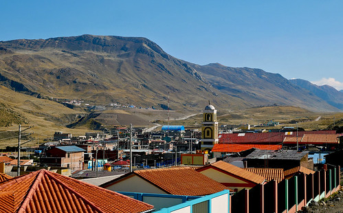
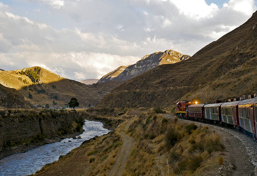 Established in 1534, Jauja, about 45-km (28 miles) north of Huancayo, was the first capital of Peru. It lost that limelight to Lima not long after, and its importance has only waned over the years, with neighboring towns like Tarma and Huancayo gradually becoming the main centers of commerce across Peru’s central highlands. The FCCA operates a spur into Jauja – a token more than anything else – and our train, barely skirting the edge of town, ignores it almost entirely. As the lights of Jauja recede into the horizon, the day draws to a spectacular close.
 Almost five thousand feet lower than Galera, Huancayo is located at a fairly respectable altitude of 10,699 feet or 3259 meters. The Capital of the Junín Region, and the fifth largest city in the country today, Huancayo is essentially an overgrown Andean town, lacking the charm of Cusco or the setting of Puno. A couple of churches, a handful of squares, and some bustling markets make up the city center, all of which can easily be covered in about half a day. A trip out of town though, or rather, to the edge of town, is a better use of your time. Torre Torre, a striking collection of eroded geological formations, lie a few miles east of the city center, and this is where the locals head for their Sunday outing, donning traditional garb, and soaking in views of the city and the valley beyond.
 Jauja, despite its heavily diminished standing today, does boast of an airport, which in fact is the only one in the entire Region of Junín. The terminal building at Francisco Carle Airport though appears minuscule in comparison to the LATAM A319 that’s just landed there. The flight from Jauja is short but stunning, and less than 30-minutes after take off, the lower reaches of the Andes are gradually being swallowed by the country’s infamous coastal fog, signaling the onset of our descent into Lima.
 Having checked off another legendary railroad on the bucket list, and as an early birthday celebration, I’m treating myself to the tasting menu at Kjolle, the sister restaurant to the much-hyped Central, in the Barranco neighborhood of Lima. The meal, nine courses long, has been incredible thus far. Every course replete with unexpected flavors and textures, with most, if not all of the ingredients, sourced from the Amazon, and also, fittingly enough, from the Central Andean region of Peru.
A full set of pics from my trip can be seen on my Flickr

What was the cost of the classic vs tourist fare?
Got introduced to Brat’s Ramblings by Bhavjit (the guy in your very first 2006 blog!). Have to say that I am extremely impressed by some of the places you have ventured including Cuba, Mongolia and Tibet travel. I love to travel myself and would love to connect ….
Brat:
“San Bartolomé is the only single ended one, meaning that all locomotives must be turned here”
In spite of the Flickr image, I was not quite able to understand what you mean by “single ended one” – I thought that all switchbacks were single ended.
Maybe it will help me if you can explain relative to the switchbacks between Estacion San Pedro and Poroy, which you have also undoubtedly travelled on.
Thanks!